Introduction
On long, committing outdoor adventures, its great to have information. Weather forecasts in particular can help you plan when to go for an objective, stay at camp, or otherwise revise your plans. Cell phones can do a great job filling this void where service exists. However in many backcountry regions and parks, cell reception is not reliable or non existent. Even with cell signal, many regions do not have the best weather forecasts by virtue of being primarily unpopulated.
The idea behind the ImagiSat project is to enhance decision making in the backcountry by both improving weather forecasts as well as their delivery to remote locations. To do this, I am working on a satellite enabled device which works with an iPhone or on its own to enable two-way communication anywhere in the world. These devices are not new, but are still expensive to purchase and operate as well as heavy and bulky to carry around. For this concept to work, the device needs to be as simple, unobtrusive and lightweight as possible yet with enough value to justify bringing it. Its core function will be to receive the most accurate short-range forecasts possible along with any realtime alerts indicating hazardous conditions. Along with this, a user will be able to send and receive short text messages, update friends with their location, and log current weather and lightning activity on the device.
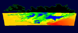
To provide better short term forecasts in regions with poor coverage, the idea is to run our own high resolution weather model customized to the locations we travel. By focusing only on the regions we are interested, say Banff National Park, we can run a much higher resolution model than normally run by government agencies tasked with forecasting for hundreds of cities. By using GPS data from the ImagiSat, a forecast can be retrieved within a kilometer of the location or less.
Example 1 km model run showing 2m above ground temperature for the south coast of Iceland.
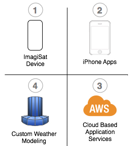
To organize this, I have split the project into four components:
- The ImagiSat hardware
- iPhone apps for the device interface and messaging
- Web application infrastructure to manage interaction
- Custom weather modeling and high performance computing
Over the next few months I will break each component out into more detail as they develop. All code and schematics will be available on GitHub under a GPL license.

